
How can a seal track climate change?
PRI's The World • June 3, 2019
Weddell seals dive almost 2,000 feet below the ocean’s surface. Elephant seals go even deeper – more than 3,000 feet. That means if scientists equip them with sensors, the seals are ideal for measuring the ocean’s temperature at different depths. And perfect for tracking the layer of slightly warmer water found deep below the ocean’s surface that’s melting West Antarctica’s glaciers.
This February and March, scientists on the research vessel the Nathaniel B. Palmer tagged 12 animals off the coast of West Antarctica with transponders about the size of a smartphone. Each powered by a single D battery, these transponders send 250-character strings of data whenever the seals surface from a dive. That string of 0s and 1s sends their location, the depth of their last dive, and the temperature and salinity of the water from that dive via satellite in near-real-time.
Related: Is Thwaites Glacier doomed? Scientists race against time to find out.
An oceanographic reading from a ship in the Antarctic can tell scientists about that one specific location — but the seals spread out and give “fantastic spatial coverage” even in the Antarctic winter, explains lead scientist Lars Boehme of the University of St. Andrews in Scotland.
The water in the Antarctic doesn’t simply get colder as you go deeper. In some places, it actually grows warm with depth, which is why deep-diving seals are good at tracking its changes.
Here’s what the seals can measure:
Surface / 0 FT
(PSU stands for Practical Salinity Unit and measures how much salt is present in seawater. On average, seawater contains roughly 35 PSU.)
Surface water is warmed by the sun after winter sea ice is melted. It’s warmer and slightly fresher than the underlying winter water.
Seals are tagged at the end of the molting season, toward the end of Antarctica’s summer. Their transponders will stay on for about a year until they molt again.
Related: These high-tech seals are charting future sea level rise
The team of scientists looked for seals hauled out on three island groups and on pieces of floating sea ice near West Antarctica’s Canisteo Peninsula. This year, the team caught 20 seals, but tagged 11 Weddell seals and 1 female elephant seal. They anesthetized them and attached transponders to the backs of their heads with epoxy before releasing them.
Boehme, who has to secure multiple permits and go through ethics reviews before he can tag any animals, said the project serves two purposes: The data collected paints a picture of the water temperature around the Antarctic, and where warmer water may be flowing toward ice shelves and melting them, but also records the seal’s behavior for other science.
200 Meters / 657 FT
In the summer, this water is colder than surface water. In the winter, it’s about the same temperature.
400 Meters / 1,312 FT
Here, the water begins to get warmer and saltier. It’s starting to mix with the underlying circumpolar deepwater, the layer of warm water thought to be melting West Antarctica’s glaciers.
Weddell seals like to forage for food in this zone and can spend up to 20 minutes here before returning to the surface.
600 Meters / 1,969 FT
This is the maximum depth that Weddell seals will dive. The water at this depth is solidly above the freezing point of freshwater and all marine animals can easily cope with this environment.
800 Meters / 2,624 FT
This water is the circumpolar deepwater. It's slightly saltier than the water above it, and its higher density keeps it from rising in the water column. Scientists believe changing winds are pushing this warm water up from the deep ocean and onto the shallower continental shelf in front of Antarctica, toward Thwaites Glacier and the West Antarctic Ice Sheet. Exactly how this happens isn’t well understood, and data from the seals will help them figure it out.
1,000 Meters / 3,280 FT
This is as deep as elephant seals will dive. It’s also where much of the warm, circumpolar deepwater settles into trenches in the seafloor and is then funneled toward Thwaites Glacier.
The data the seals collect is transmitted to a satellite as soon as the animals surface.
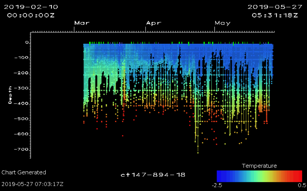
“It’s pitch black in the polar winter, it’s -30 Celsius, you have 100% ice cover and they still find these little holes and cracks [in the sea ice] and come up to the surface and dive down again,” Boehme says. “And a couple hours later, I have the data. It’s near real-time data, how the ocean looks in Antarctica.”
Small changes in the water temperature – even .5 C — can have drastic effects on the melting of the glaciers.
“We need data because, for us, it just looks like water,” Boehme explains.
This is the first in a series of deep dives into the science and people of the Nathaniel B. Palmer’s 2019 voyage to Thwaites Glacier in West Antarctica. Listen Mondays on The World and check back online through June to learn what scientists found as they studied the sea that’s melting this Florida-sized piece of ice. Follow us on Instagram for videos, quizzes and more photos from Thwaites.